 |
Lola Oñang (Gorgonia, wife of Lolo Lucio, holding the basket) with her children
(women wearing indigenous costumes) |
Ongsiaco Family Tree (1 of 2)--work-in-progress
http://www.flickr.com/photos/65007685@N08/7680125910/sizes/k/in/photostream/
Ongsiaco Family Tree (2 of 2)--work-in-progress
http://www.flickr.com/photos/65007685@N08/7680127708/sizes/k/in/photostream/
Ongsiaco Family History in Nampicuan
Contemporary history has not been favorable to Nampicuan. Several years ago, I had a conversation with the late P. O. Domingo, former Chairman and CEO of the University of the East. When I informed him about the family farm in Nampicuan, he said he hailed from Paniqui, Tarlac and recalled, when he was a young man, the reputation of Nampicuan as a haven of cattle thieves. Another mark of Nampicuan’s infamy was due to the criminal exploits of the late Jose "Pepe" Saclao, Public Enemy No. 1. Born and raised in Nampicuan, Pepe fancied himself a modern day Robin Hood but was just another gun-wielding lackey of corrupt politicians.
Today, Nampicuan is a quaint and peaceful rural town in Central Luzon that boasts of a pedigreed past known to a few families that were privileged to own what was once known as Hacienda Esperanza. Covering an area of 39,000 hectares (part of which was the entire Municipality of Nampicuan that did not yet exist), Hacienda Esperanza was the largest tract of land owned by a single individual in the entire history of the Philippines.
The Spanish royal land grants were responsible for two huge haciendas in Central Luzon: Hacienda Luisita and Hacienda Esperanza. Hacienda Luisita in the Province of Tarlac, which encompassed territory in the towns of Tarlac, La Paz, Concepcion and Capas was a royal grant given to Tabacalera Company in 1880—acquired with the sugar mill, Central Azucarera de Tarlac, by Jose Cojuangco Sr. in 1957 with the help of the Philippine Government. Hacienda Esperanza, nearly 40,000 hectares which encompassed territory in four provinces—Pangasinan, Nueva Ecija, Tarlac and the Mountain Province—was a royal grant given to a Spaniard in 1863.1
Sometime in 1878,
Francisco Gonzalez, a prominent Spanish mestizo from Baliuag, Bulacan, bought out the original Spanish owners
2 of Hacienda Esperanza. Then, in 1893
3, Francisco Gonzalez (allegedly due to substantial gambling debts) sold nearly half of Hacienda Esperanza to Marcelino de Santos and Lucio Ongsiaco. De Santos and Ongsiaco were not only business partners but also brothers-in-law by virtue of Marcelino’s marriage to Lucio’s sister (Irenea Soriano Ongsiaco, a.k.a. Neneng, who died of child birth in 1881, leaving Marcelino with 5 children). The portion of Hacienda Esperanza they received was located in the Province of Nueva Ecija (including most of Nampicuan and part of Cuyapo) and in the Province of Tarlac (including part of Anao and part of San Manuel). All in all, what was to be known as the De Santos, Ongsiaco, Lim Estate covered nearly 15,700 hectare
4 of virtually uninhabited land at that time.
In time, the Estate was divided among its owners. Lim, the industrial partner of De Santos and Ongsiaco, and the encargado or foreman of the Estate, was given approximately 1,500 hectares in the vicinity of San Manuel, Tarlac. De Santos received more than half the balance of approximately 7,700 hectares, allegedly because he asked for a disproportionately larger area of land due to his having more children than Ongsiaco at the time of the division—to which Ongsiaco obliged. Ongsiaco received approximately 6,500 hectares, which comprised most of Nampicuan and some parts of Anao and Cuyapo.
Lucio Ongsiaco had nine children with his wife Gorgonia Velasco. As was the custom in those days, the male heirs typically inherited more than the female heirs. Hence, Caridad Velasco Ongsiaco (my grandmother, affectionately known as Lola Ego), one of the daughters of Lucio and Gorgonia, inherited a disproportionately smaller area of approximately 600 hectares of her father’s rural landholdings—mostly in Nampicuan with a few hectares spilling over to Cuyapo.
Towards the end of the Second World War when food was extremely scarce, my Lola Ego bartered a valuable ruby encrusted ring for an emaciated cow just to be able to feed the family. Thereafter, she swore that this would never happen to the family even in the most desperate of times. Thus, shortly after the War, my Lolo Ego purchased a few heads of cattle, which was the genesis of our modest cattle operations at the farm.
Caridad was married to Manuel Viola Gallego (affectionately known as Lolo Ego), who, in 1953, registered Caridad’s rural landholdings to Gallego Institute of Agriculture and Industry, Inc., a Philippine corporation established for the advancement of agricultural education in Central Luzon (“GIAI”). Lolo Ego,
who was the Secretary of the Department of Instruction under the administration of President Quirino, established a private agricultural school in Nampicuan (GIAI) when there was no public high school in the municipality. Having been a working student in his youth, Lolo Ego enabled underprivileged high school students, who could not afford to pay tuition in cash to pay in the form of labor or tasks assigned on the experimental school parcels of the farm, which also enhanced the learning of the students. This innovative practice eventually waned after the establishment of a public high school in Nampicuan. However, thousands of GIAI alumni credit this “work to study” program, in the absence of which they would not have been able to complete their high school education.
The years that followed saw the destruction of rural landowners whose lands were planted to rice. The burgeoning Philippine democracy saw the rise of the politician who sought the vote of the common man at the expense of landowners. Forced distribution of land or institutionalized land-grabbing, ostensibly known as agrarian reform, was and continues to be imposed by the government.
The often touted and imbecilic justification for the continuing existence and intervention of DAR with respect to the use of land for purposes other than agriculture is “food security.” Yet, one only needs to glean from the exceptional performance of the agricultural sector in the Netherlands (41,543 km2, 59% vulnerable to flooding by the sea) and Israel (22,145 km2, more than 60% desert) to determine that food security in the Philippines (300,000 km2, plenty of tropical agricultural land) is less a function of land area but more a function of intellectual equity; in particular, the nationwide implementation of “smart” (not necessarily expensive) agricultural practices that yield higher value crops with significantly less land--which the Philippine government has failed to execute over nearly five (5) decades (and counting) of CARP (in contrast to the agrarian reform programs in countries like Japan, South Korea, Taiwan and China, which were completed in less than ten (10) years). Hence, in spite of this unnecessarily drawn-out social experiment of “robbing from Peter to give to Paul,” the Filipino farmer remains among the poorest in our society. Further, where in the civilized world would agricultural land be forcibly taken from the owner by law for making the mistake of planting a single grain of rice? This would explain why the Philippines has been a net importer of rice for decades. It is therefore appropriate that the DAR’s mandate to acquire and distribute agricultural land has finally expired on June 30, 2014. An enlightened legislature would perform a great service to its constituents in the less developed countryside by (a) eliminating the useless “gatekeeper” function of the DAR (with respect to DAR Excemption Clearance or DAR Conversion) and, indeed, (b) abolishing the DAR altogether. As such, undeveloped municipalities (especially those in close proximity to expressways or similar infrastructure like Nampicuan) will be encouraged to unleash their full economic potential in the absence of the unnecessary and counterproductive red tape currently still imposed by the DAR.
Today, Nampicuan is comprised of small tracts of land owned by many individual farmers (beneficiaries of the De Santos, Ongsiaco, Lim Estate), who continue to produce rice, among other agricultural produce, for domestic consumption. GIAI, which we now fondly call Rancho Cardidad (in honor of my grandmother), is the only descendant entity of Hacienda Esperanza that maintains a presence in Nampicuan. In 2011, at the behest of Manuel O. Gallego Jr. (my father), GIAI donated its high school of over 60 years, to the Roman Catholic Diocese of San Jose, Nueva Ecija, which, in turn, has committed to bring to bear its resources to provide quality Catholic education to the youth of Nampicuan. Today, the school is known as
St. Pius X Institute of Nampicuan.
I have also embarked on an agri-turismo initiative complementing our grass-fed livestock (great steaks!) with hot air ballooning, among other modes of recreational aviation.
Below are aerial photos of Rancho Caridad:
Rancho Caridad, Nampicuan
Taken from the northeast side of the airstrip
Rancho Caridad, Nampicuan
Taken from the northeast side of the airstrip
Rancho Caridad, Nampicuan
Taken from the southeast side of the airstrip; Nampicuan Public High School
across the Ranch along the Anao-Nampicuan-Cuyapo provincial road
Rancho Caridad, Nampicuan
Taken from the southeast side of the airstrip
Diagonal Airstrip (work-in-progress)
Taken from the northeast side of the airstrip
Diagonal Airstrip (work-in-progress)
Taken from the southeast side of the airstrip, along the path of dominant wind direction--
a significant safety feature for microlights
Postscript:
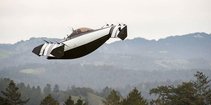
On the morning of February 9, 2015 at the Rancho Caridad airstrip, I crashed my ultralight shortly after take-off. It was a classic "pilot error" and entirely my fault, which could have been avoided if I had just followed my usual pre-flight procedure. But that's water under the bridge. Although I have been banned by my family from flying, I have plans to secure the dealership of the BlackFly in the Philippines. The BlackFly is perhaps the most exciting development in personal flight today and, by Jove!, Rancho Caridad will be its home in the Philippines. Click on this link to see its official launch on video.


